

Altamont Road: Tigers and humble origins to billionaires
Bombay: A Place in Time
Altamont Road, India’s Billionaires’ Row, was long a peaceful tree-covered locality meandering up the southern slope of Cumballa Hill. Almost definitely named so after one Colonel Altamont (yes, spelt ‘Altamont’ not “Altamount”!) who lived in a home that went by his namesake a little up the hill, it would be easy to deduce that the translation of the name into “high hill road” is apt, but easier said than done! The earliest reference comes from the year 1865, the peak of a cotton boom in Bombay that had seen its wealth and prominence skyrocket, when Altamont was being let out on rent at Rs. 1000 per month, an astounding sum for its time (and an indication of demand even in a then-obscure part outside the fort area) and hence deemed worthy of recording.
1865 was also the year that the American Civil War ended; Britain lifted its trade embargo on the US and cotton prices in Bombay plummeted, rendering many of the richest men in town bankrupt virtually overnight (due to various factors which are too detailed to enter into here.) But what changed Bombay forever within this time period is that the fort walls were ordered to be brought down by then Governor Bartle Frere, whose brother William had lived in Altamont in the 1850s, described as “a jolly man, which could scarcely be said of Sir Bartle, and very popular”. Other British-era references of Altamont, of which there are scarce numbers, record parties such as one where William Wordsworth (Jr.), the son of the poet recited a poem wherein a writer jibed that “he had never been to Scotland, but from the hills of Cumberland he had once “a glimpse of the Promised Land”! So, on and on life went by in this quaint neighbourhood.
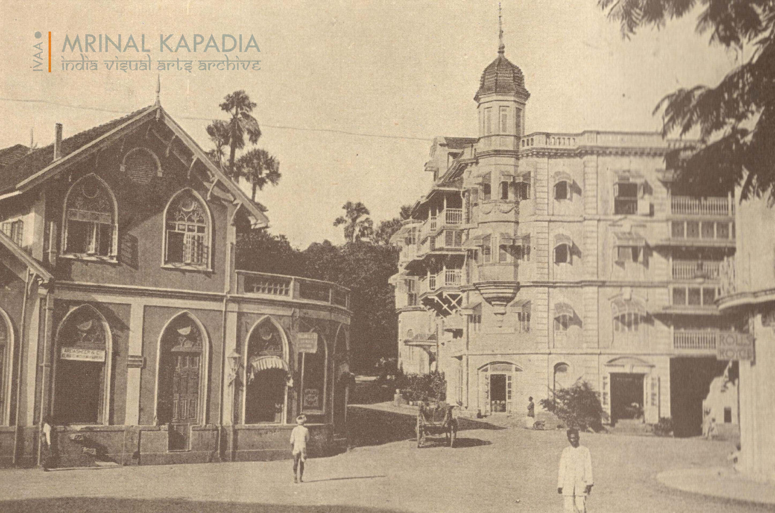
Shifting gears – looking through my bedroom window during peak COVID, I would wonder at how the quiet, even in a turbulent time, could render a place peaceful. The view that greeted me was virtually what we see here in this accompanying early 20th century view – left to right, is the Manize bungalow, Maskati Corner, and the edge of Kwality House, all at Kemp’s Corner, with the commencement of Altamont Road in the centre. A quaint view of bygone times in this neck of the woods, the Manize bungalow was largely (but not completely!) demolished in the 1960s during the construction of the Kemp’s Corner Flyover that went right over it, leaving the road-accessible shopfronts to house Manize beauty parlour for many years, before the final remnants were very recently demolished. Confusingly enough, the road that used to envelope the bungalow pre-flyover days was named Hermitage Pass (also the former name for Kemp’s Corner, still to be found in contemporary BMC surveys), but the 18th century Hermitage bungalow was to be found on the other side of Woodlands, at the site of Pleasant Park today, as conveyed by Mr. Vaman Apte, whose family lived in the adjacent Woodlands bungalow before its transformation into a skyscraper, adding that his mother clearly remembers this.
Maskati Corner, formerly named Tata Mansions, used to house Kamal Book House, where a young Buddhichand Maroo was employed for a short while before launching in the 1960s what was to become the media behemoth Shemaroo Entertainment, as confirmed by co-founder and brother Mr. Atul Maru, further stating that their origins were very humble, and grew over time. The building today houses residences as well as a host of commercial establishments. The Rolls Royce sign of Kwality House can be seen on the right of the image, covered extensively previously in this column.
Gone are the days when characters like “sau eedu” (hundred eggs!) lived in the vicinity mid-20th century (described in the unputdownable ‘Altamont Road and other True Stories’ by Sheryar Ookerjee, a rib-tickling look into the hyperlocal residents of the time) and tigers would amble up the rough Altamont Road path two centuries ago. To cap off, here’s a century-old account of the view from the cliff at the end of Anstey Road, off Altamont Road, considered one of the best the island had to offer: “From Cumballa Hill, the view to the east includes the whole native city, the hill of Mazagaon… To the left lies the industrial area, with its high chimney-stacks and mill roofs… On the west side Cumballa Hill slopes down to the shore, where, close to the Hornby Vellard, the Mahalaxmi temples command attention.”
(Picture and article by Mrinal Kapadia, resident of Cumballa Hill, he is a collector and researcher, and can be reached on mrinal.kapadia@gmail.com or via Instagram on @mrinal.kapadia)


HELLO, Nice to meet you. I read your article above with much interest. I thought you might like see my comments here (with images):-
https://www.facebook.com/thevoiceofmalabarhills – I made following comments on the post 20 Jan 2023; “Our People on the Hills – MRS. (CHIEF JUSTICE) SUJATA VASANT MANOHAR (RETD.)
FACEBOOK COMMENTS: with images….
___________________________________________________
Hi, does anyone have a photo of “Altamont”, the house of Sir Willam Yardley, Knight, Chief Justice Supreme Court of Judicature, “Bombay” (from 1852)..
CC : MRS. (JUSTICE) SUJATA VASANT MANOHAR (RETD.) – first woman Chief Justice of the Bombay and Kerala High Courts.
That the Malabar/Cumballa street was named after it, is a pretty safe call I reckon.
In fact – “The once unspoiled Altamont Road was originally named after a Bungalow called Altamont that stood on this magnificent tree-canopied avenue.” ref: The Voice of Malabar Hills Hills 20 Oct 2014 ( ‘the tenth most expensive road on the planet’.)
Various Almanacs, give his addrees there. Allan’s Indian Mail has “Lady S Yardley” giving birth there in 1849 (see attached). So Yardley was there before becoming Chief Justice.
I only have a long distance photograph c1853 of it : “Sir W Yardley’s house in the distance”, from the Chirstchurch steeple, Byculla (by my photographer ancestor, WH Stanley Crawford, “The Grove”, Mazagon). It’s the ONLY house in the distance in the frame! (see in comments.)
My GG-grandfather Stanley was the Secretary of the Bombay P’graphic Soc. and Sir Yardley was the Patron. (Stanley later went into family business of shipping agency, Malabar plantations, etc, etc).
I have shown on an 1887 map where I think Yardley’s house was – long gone (next comment). It appears from an 1855 map that it was where (or near) a “flagstaff” was, (high point for shipping coming from west I presume.)
🙂 Ian (Melbourne Aust).
___________________________________________
This is the only clear view of any house in the distance to be seen – above the tree tops. “Altamont” was on top of Cumballa hill, so the “deeper” background behind it appears to be low cloud (?). Unless, there was a much higher ridge closer to the shore and it’s been lowered by quarrying for reclaimation nearby?
And I’m reasonably sure that Stanley was taking the photo especially for Sir Yardley. Both were in Bombay Photographic Society – and why otherwise take such a nondescript photo which took such great lenghts to haul bulky photo equipment up a high church steeple!?
Surely he didn’t make a huge mistake and photograph the wrong house! It would not have made the cut to be entered in the Society’s first Journal (no.1) which was then presented to Lady Canning in 1856.
NB : “By 1855 Crawford’s interest had begun to turn toward paper negatives and he showed a large group before the Photographic Society of Bombay, of which he was secretary. The prints he showed in the society’s 1856 exhibition were so admired that the negatives were examined, bringing pleasure to the council, which, according to the Journal of the Photographic Society of Bombay, had “no hesitation in saying they are, as a whole, the finest and best collection we ever saw,” also noting that Crawford had “long borne a high name as a Daguerreotypist, and . . . some of his best specimens were on view.”
__________________________________
I have shown on an 1887 map where I think Yardley’s house was – long gone (next comment). It appears from an 1855 map that it was where (or near) a “flagstaff” was, (high point for shipping coming from west I presume.)”
Cheerio, Ian.
I have since determined to my satisfaction that the roof of the building just above the tree line is actually the new, large 2 story Servants Quarters at the Byculla Club – race course.
Yardley’s house “in the distance” and Cumballa Hills are unfortunatley much too faded/washed out to a mere blur. But with Photoshop manipulation, it can be made out, on the ridge line, between the trunk of the Brab tree and (the line of) the roof of the Byculla Club servants quarters. Cheers, Ian.
Your words resonate with a truth that feels universal — as though they’ve tapped into something deeply human.